The beautiful Marquesas Keys lie along the route to the Dry Tortugas and are only 21.6 nm west of Key West. An interesting stopover with a fairly well-sheltered but shallow lagoon the Marquesas are made up of numerous small keys arranged in the shape of a South Seas atoll. Use binoculars to locate a suitable entrance. If you have a shoal-draft boat, a high tide and an overhead sun, then you might want to try it; otherwise, don't risk it and anchor outside. You are likely beyond VHF range for assistance.
Before departure from Key West skippers should consult the most up-to-date Local Notice to Mariners. In addition to changes in aids to navigation in the area, check on any military operations in the restricted area west of the Marquesas Keys. The Coast Guard can be reached on VHF Channels 16 and 22A in Key West.
Enjoy a dinghy ride through the maze of passages in the Marquesas atoll but do not go ashore. This is a marine sanctuary and signs on the shore prohibit you from landing. This area is known for the famous Spanish treasure ship, The Atocha, which sank just to the west of the Marquesas in the Quick Sands.
Navigation Notes
Because of erratic and sometimes severe weather in the area (unpredicted fronts packing high winds are not that unusual) passage to the Dry Tortugas requires planning for the unexpected. Weekend trippers, Caribbean-bound cruisers and fishermen alike often find themselves holed up for a week or more in the modestly protected harbor off Garden Key in persistent 25- to 35-knot winds from stalled fronts in the Gulf of Mexico or off the Cuban coast. If weather conditions are less than ideal a trip to the Dry Tortugas should be postponed. (Or opt for a seaplane ride!)
In all conditions boats bound for the Dry Tortugas should be equipped at a minimum with a VHF radio, depth sounder and GPS unit. Careful checking with NOAA radio forecasts before and during such a trip is essential for your safety. The National Park Service posts daily NOAA weather reports at the docks at Garden Key.
One route to the Dry Tortugas runs south of the Marquesas and the other to the north. The southern route permits easy access to the best anchorage in the Marquesas. Check your charts for shoal areas and stay clear of both keys. Boca Grande Key is approximately 12 nm west of Key West.
The southern route leaves Key West southbound via the Main Ship Channel and enters the Southwest Channel at flashing green "15." From flashing green "15" take a heading of 236° magnetic for the 5.3 nm run to point north of green daybeacon "3" marking shoal charted as Middle Ground. From this point adjust your course to 277° magnetic for 10.3 nm through West Channel to the southern terminus of the Boca Grande Channel, about 2.5 nm north of Coalbin Rock. This leg runs south of Man Key and Boca Grande Key and north of Parsonage Shoal. The route to the Dry Tortugas continues for another 42 nm to the Southeast Channel approach.
The Boca Grande Key anchorage is to the north. Watch for shoals off the key's west flank on approach. Continuing west it is about 4 nm from the Boca Grade Channel at 277° magnetic to the Marquesas Keys. Keep well north of Coalbin Rock. The passage to the Dry Tortugas continues at 277° magnetic for another 10 nm passing south of the Marquesas and The Quicksands.
The Marquesas atoll can be approached from either the northern route or the southern route. You can switch between these routes using the north-south Boca Grande Channel located approximately 2 nm west of Boca Grande Key and identified by green daybeacon "1" to the north and red daybeacon "2" to the south. There are some promising-looking entrances to the Marquesas Keys lagoon on the charts. Only extreme shoal-draft vessels should attempt entry and be prepared to get yourself off the bottom if you run aground. You are likely out of VHF range for assistance here.
Anchorages
If you choose to take the southern route you can stop off and anchor to the northwest of Boca Grande Key near green daybeacon "17" in 10 to 16 feet at MLW. This site can accommodate boats with deeper drafts. Choose your location based on wind direction. There are no other intermediate anchorages, facilities or supplies of any kind after leaving Key West.
At the Marquesas Keys try to figure out the winds and then anchor in the lee of the islands. Some charts show Mooney Harbor Key as having room for several boats but that is deceiving. Shallow draft boats can snug up due west of the island in at least 4 feet MLW with exposure from the south. It is shallow but you will find excellent holding here.
An anchorage on the western side of the Marquesas Keys is comfortable in winds from an easterly quadrant. Depths of 8 to 13 feet MLW can be found fairly close to shore.
Dry Tortugas National Park
Seventy nautical miles from the nearest settlement in Key West the Dry Tortugas are the westernmost of the Florida Keys, the most remote and, in some respects, the most fascinating and beautiful. With careful preparation a voyage to the Dry Tortugas can be most rewarding.

Dry Tortugas National Park was dedicated in 1992. Its boundary now marked by an elliptical circuit of 10 large yellow buoys. Touring Fort Jefferson on your own is an option but a ranger-guided tour provides many interesting and unusual facts that will enhance your visit and understanding of life at the fort. It is the largest and best-preserved fort of the 19th-century U.S. coastal defense perimeter (8-foot-thick brick walls, standing 50 feet high and surrounding a 17-acre quad).
When visiting Garden Key by private boat you must check in at the National Park Service Visitor Center inside Fort Jefferson upon arrival. Rangers will provide a copy of the park's brochure with maps and regulations and the latest weather report. There are restrooms at the docks and beach space for dinghy landings. (Note that the landing before the dock has lots of stones, while the one after the dock is all sand.)
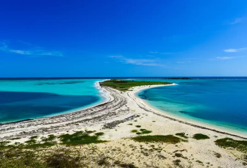
Note from WG Community: The key to a calm anchorage off of Garden Key is if the sand bridge that forms between Garden Key and Bush Key is present or not. In the photo the bridge is seen in place but this is not always the case. Many times the channel cuts through where the bridge is shown. This allow surge to enter the anchorage. It is not a bad surge but it is persistent. Asking around the Key West marinas can usually produce an answer to the bridges current condition. Bridge in place or bridge out both have advantages but for my wife who doesn't like being rocked to sleep bridge in is a prerequisite for out Dry Tortugas cruises. - Gary H.
The park is a No-Discharge Zone and park rangers may check your vessel's Y-valve. The park has picnic tables, a few charcoal grills and beautiful designated swim beaches. No services or supplies are available and all trash must be carted back to your boat.
More Comments from the WGCommunity:
Plan more days on the back end to find a weather window for your return trip. The predominant east wind can make the return trip not only exhausting but damaging to your vessel. - Richard
Dry Tortugas is absolutely my most favorite sailing destination. If there is a moderate or higher breeze, the ride in gets bumpy and visibility in the Park for snorkeling/diving is low. Go when it is calm and you will have the time of your life. Also, be aware that there are numerous new restrictions on where one can anchor or dive. For example, the great Staghorn Coral reef to the east of the fort was closed on our last visit. Even so, the water is spectacular when the wind is calm. - Brian M.
For more information on navigating the Marquesas Keys and Dry Tortugas, see Chapter 10 of Waterway Guide Southern Edition.


- 4,000 Marinas
- Thousands of anchorages
- Updated Charts
- Mile-by-Mile Navigation
- Highlighted Alerts & Cautions
- Full-Color Aerial Photographs

The Waterway Guide App Makes it easy to leave reviews, use our explorer, and view waterway guide materials all on the go!