Contributing Editor Bob423 offers an update on problem areas and solutions for transiting the ICW this fall when heading south.
Conditions along the ICW have been evolving over the summer, which will make the cruise south this year more "interesting" for those headed to warm weather for the winter. In this overview I'll cover new shoaling since last spring that may require you to consider tide and timing to get through. A complete listing of every shoal area is beyond the scope of this article but can be found in the 2024 ICW Cruising Guide available in digital form in the Waterway Guide mobile app and from Amazon.com in paperback.
You will find repeated references to Bob423 tracks, which are GPX files that can be downloaded for free to use in any navigation program or app. The tracks show the deepest water path from Norfolk, VA to Miami, FL and are updated throughout the year as shoaling changes on the ICW. Aqua Map has a one button feature to load and automatically update the Bob423 tracks.
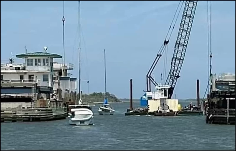
The Coast Guard uses statute miles from starting at mile zero in Norfolk, VA, to identify locations on the ICW. For example, in the left graphic, Charleston is shown at mile marker (MM) 467. The shoal areas covered in this article will use the same convention.
When I skip over areas, it does not mean there have been no groundings, but rather, the area has not changed significantly since spring. The status of all shoal areas can be found via the Waterway Guide Alert icons in Aqua Map next to each problem area or by accessing Waterway Guide Explorer (see the yellow exclamation marks in the link). Listed below are five important changes along the ICW for the 2024 fall migration.

The extreme northern edge of the channel has the deepest water, at 7.0 MLLW. It's down to 5.0 MLLW if you go straight through, honoring G5A. The Bob423 track is shown as a blue dotted line on the USACE survey as shown in Aqua Map that dodges the shoaling near G5A.
MM 238.2 Browns Inlet: 9.0 MLLW on Bob423 track as of 9/27/2024, 4.5 MLLW in the channel
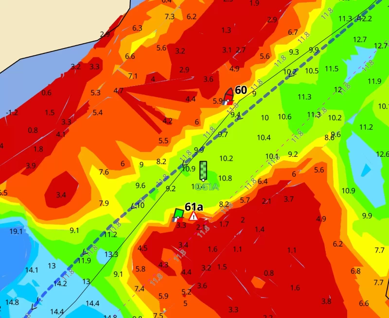
G61A was off station for several months but has been relocated northwest of its charted position, about 75 feet northeast of the location shown on updated charts such as in Aqua Map. The green checkered icon shows the location seen on 9/27/2024. The shoal by G61A continues to grow and I expect the gap to narrow as the migration season continues. The Bob423 track favors the red buoy side of the channel, giving the growing shoal from G61A a wide berth.
MM 240.6 Onslow Swing Bridge Replacement
The Onslow Swing Bridge is being replaced and there will be ICW closures at times for boats exceeding 15 feet in height or 20 ft in width. The schedule is still in review, but restrictions are due to start October 7, 2024, and extend through December 20, 2024. Stay abreast of the closure schedule by monitoring the Waterway Guide Alert for the Onslow Bridge. The link will be updated as soon as an official schedule is announced.
MM 244 New River Inlet: 9 MLLW on Bob423 track as of 7/15/2024, 4.8 MLLW in the channel

The ICW channel shoaled to 4.8 MLLW so the Bob423 track was moved to the "dip route" and the R72A was relocated shortly afterward to direct boaters away from shoaling in the main channel.
MM 321.5 Lockwoods Folly: 8.0 MLLW on Bob423 track as of 9/1/2024, 5.0 MLLW in the channel.

Lockwoods Folly has shoaled in the channel to 5.7 MLLW. Since shoaling will only get worse, follow the Bob423 track by the shore to avoid the shallow water. As of 9/25/2024, the ATONs still mark the old, straight through route, but will be moved to the shore route as shoaling worsens. ATON locations may not match your chart, but the Bob423 track shows the way.
MM 460.3 Isle of Palms: 4.5 MLLW on Bob423 track as of 8/1/2024, 0.7 MLLW in the channel

The Bob423 track follows the northern edge of the channel for 4.5 MLLW. There are spots down to 0.7 MLLW in the channel. You will need tide to get through, but there's an alternate route for 6.7 MLLW (see second photo).

The detour route is shown as a red dotted line and is included in the Bob423 track for the area. Dozens of boats have taken the route for 6.7 MLLW.
The American Cruise Lines boat Constitution took the detour route when she couldn't get through the ICW channel a little past high tide.
There are no changes to the many shallow areas south of Charleston until you come to Ponce de Leon at MM 843. They are all in the 4.5 to 5.0 MLLW range like last year on the Bob423 track - but you can easily find less water off the track.
MM 843 Ponce de Leon: 6.4 MLLW as of 5/7/2024

The gap is very narrow on the ICW channel by R18 and R18A. A change of 30 ft to starboard or port off the Bob423 track can lead to 2 feet less water. The 9/14/2023 USACE survey is shown but does not show the increased shoaling and the narrowing of the gap. Adding to the challenge are oncoming boats and the 2 kts of current pushing you sideways as you try holding a line. A second route used by local fishermen is shown as a red dotted line for 10.9 MLLW that has not shoaled in the past, even when the ICW channel was down to less than 5 MLLW.
What about all those other infamous shallow areas?
A short article cannot cover all the shallow areas that present problems to cruisers. The intention was to alert ICW boaters to changes from the spring of 2024 that may impact their ICW fall migration plans. Complete coverage of all shoal areas can be found in the 2024 ICW Cruising Guide, offered in digital form in the Waterway Guide mobile app and in a paperback version on Amazon.com.
Be sure to join the ICW Cruising Guide Facebook page where members report on what they see on the way south this fall. By joining, you get the benefit of members' eyes and ears on the ICW and can post what you see too - to the benefit of us all. It's a good way to stay abreast of problems that may affect your cruise and keep surprises at bay. After all, the ICW should be fun - and all the information you can get helps.


- 4,000 Marinas
- Thousands of anchorages
- Updated Charts
- Mile-by-Mile Navigation
- Highlighted Alerts & Cautions
- Full-Color Aerial Photographs

The Waterway Guide App Makes it easy to leave reviews, use our explorer, and view waterway guide materials all on the go!