The noon to 1:00 pm openings on weekdays are on demand. Vessels that can clear the 15 foot height of the new bridge can transit at any time. Openings outside the times mentioned will be on top of the hour from 7:00 am to 7:00 pm and on demand from 7:00 pm to 7:00 am.
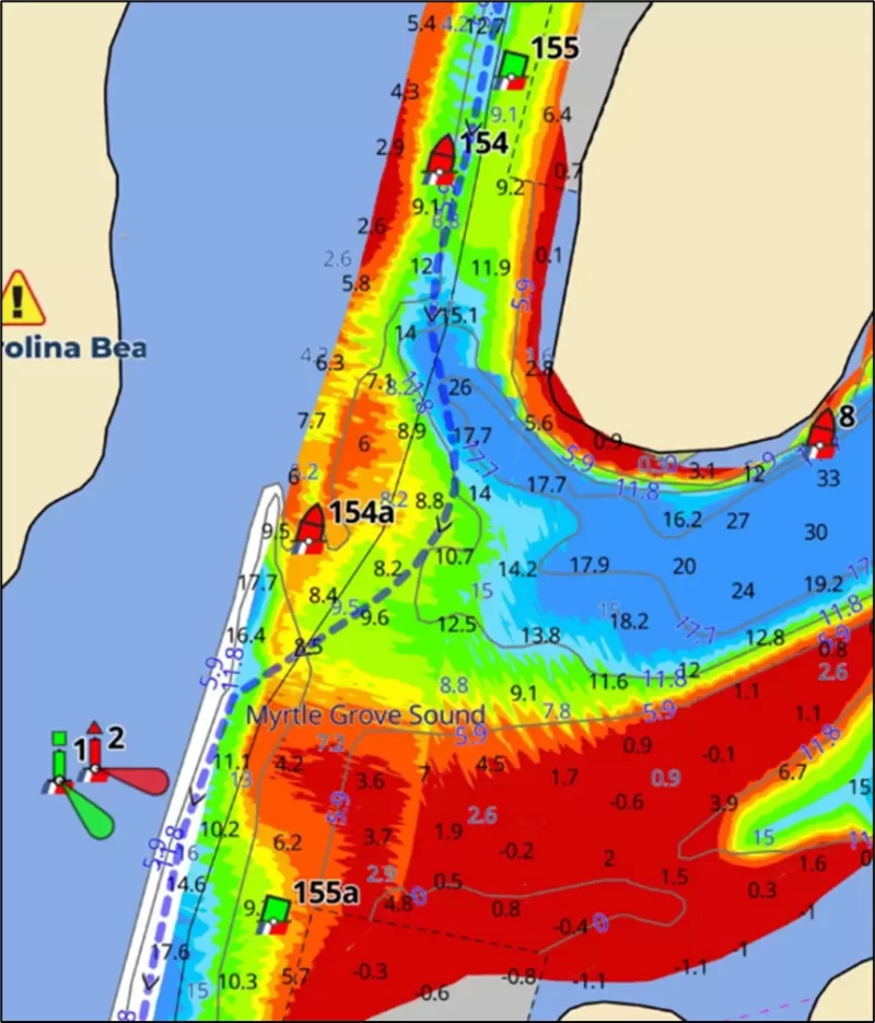
2 – MM 293.7 - Groundings reported at ICW Crossing at Carolina Beach Inlet
Shoaling has recently pushed out from R154A and G155A, requiring sweeping turns to avoid shallow water. You must stand off R154A by 200 ft and turn west sharply to avoid shoaling by G155A, passing 250 ft off. See the Bob423 track shown in the photo for details of the turns. The Bob423 track in blue showed 7.7 MLLW as of 10/10/2024.

3 – MM 320 - Groundings reported at Lockwood Folly River crossing.
The NOAA channel is completely shoaled. Boaters must go outside the channel to the green side. R36 has been reported off station to the northeast, leading boaters into the shoal area. The USACE survey chart shown is dated 9/24/2024 so the shoaling is probably worse than pictured.

The channel under the U.S. 1 Bridge (red circle) will be closed to all boat traffic on Monday, December 9, from 8:00 am to 4:00 pm to allow for some of the beams of the final span of the bridge to be set in place. This project will take two days, with the second closure currently projected for Friday, December 20.

Use Waterway Guide's Navigation Alerts to plan your trip, adjusting timing for the tide you need. Follow the Bob423 tracks in Aqua Map to ensure you get the maximum depth possible. The color-coded depth charts are from USACE surveys in Aqua Map. The areas mentioned in this Bulletin are only the recent changes, not a complete picture of all shoaling. Additional resources are available in the Waterway Guide digital publication 2024 ICW Cruising Guide and at Bob423 Guides.


